

Every town and city in North America has extensive and complex networks of underground and aboveground facilities. In the not too distant past, those facilities typically fell into one of three categories: water, sewer, or natural gas lines. But with steady technological developments over the last century, more and more utilities are being installed and, thus, buried. This trend is particularly obvious in the telecommunications space, where aerial telephone lines and communications equipment have been complemented or replaced by underground service wires, copper cables and fiber optics cables that supply the phone and internet connection essential to the functioning of today’s society.
There is, of course, more to the increasing tendency to bury facilities than aesthetic considerations – buried facilities are less susceptible to storm damage and the harsh effects of exposure to weather conditions. The flip side, however, is that as more facilities go underground, the underground network becomes more complicated, making accurate identification of each more difficult. Since utility workers are unable to see buried assets directly, they rely on maps and information provided by others, and some of that information is antiquated or inaccurate. This often results in unintended damage to buried lines. According to the Canadian Common Ground Alliance (CCGA), undertaking a digging project without knowing where underground infrastructure is located is the most frequent cause of damage to buried infrastructure. That damage is estimated at $6 billion annually for North America alone.
Addressing the Accuracy Gap: Better Tools are needed
With such astronomical costs, damage prevention becomes an economic imperative for all involved in the utilities industry. When other consequences like injuries and fatalities are factored in, it becomes clear that damage prevention is not just an industry issue, but one that affects everybody. Precise and accurate utility locating is therefore of critical importance. Yet, one of the defining characteristics of utility locating is that practitioners practically work unsighted. Unable to directly see what lies underneath, precise locating is difficult to achieve and can lead to damaged infrastructure.
For years, the wealth of data provided by Geographic Information Systems (GIS) has been used to mitigate this disadvantage. With GIS-driven maps, locators can identify the general vicinity of cables, lines, pipes, valves, meters and other facilities. But while it is very useful, GIS data delivered in the form of traditional overhead maps is not enough.
Addressing the Problem through Augmented Reality
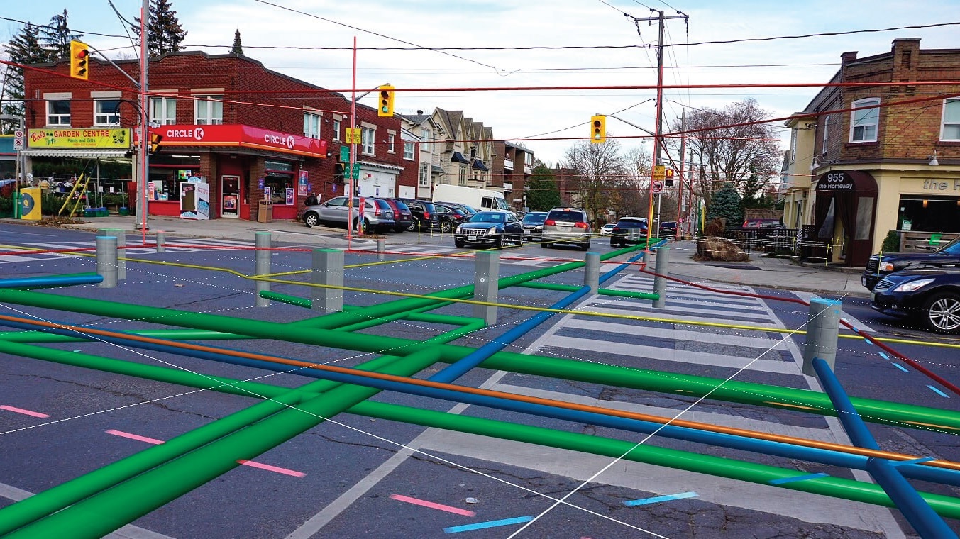
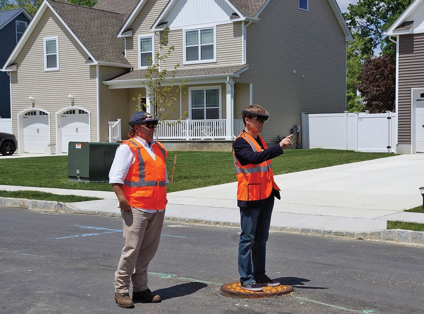
Over the years, efforts have been made to use technology to improve upon what GIS offers. Recent technological developments have allowed GIS data to be combined with other technologies to address one of the greatest needs within the locate industry – providing an unobstructed view of the physical world beneath the pavement. In this regard, Augmented Reality (AR) has shown the most promise, as it enhances visualization of data at street level.
In a recent study using vGIS (www.VGIS.io), a leading GIS-based AR software, 84 percent of the research participants (locate professionals) found that AR made locate jobs easier, with the system helping to prevent issues in 49 percent of cases. Furthermore, they found that AR has benefits even in environments with limited GIS data. This is because with AR tools, locators can see an unobstructed physical world in front of them, as well as holograms of lines and pipes underground. Simply following the holographic projections on the ground enables locators to perform their jobs faster, more easily, more safely and more accurately.
By harnessing the capabilities of three different technologies – AR, GIS and Microsoft HoloLens – locate technicians gain access to a new, integrated and more advanced technology that increases situational awareness. And in providing greater situational awareness, AR enables industry professionals to have a greater understanding of their surroundings, which mitigates the risk of missed lines due to human error and the subsequent damage to infrastructure.
Applying AR to the Damage Prevention Industry: Potential Use Cases and Impact
When underground telecommunication facilities are damaged, it is costly for everyone involved. By the same token, the use of AR delivers significant gains for all damage prevention stakeholders in different ways:
• Telecom Companies and Public Utilities: Infrastructure owners want to avoid damages while reducing their costs. With AR technology, they can more easily find and repair infrastructure, avoid accidental line cuts during excavations and address GIS documentation gaps. With better visualization, they can also create time saving and safer records of their infrastructure. Having such records is also useful for planners and a wide array of groups involved in spatial development, as utility location information will be readily available for public or private developers and municipalities during planning and design stage of infrastructure projects.
• One Call Centers: Providing up-to-date information is one of the challenges One Call Centers often face. By crowdsourcing data from front-line workers equipped with AR tools, One Call Centers can create better documentation and improve planning. This will ultimately translate into more accurate information at their disposal, which will create a higher level of confidence in locate operations and increase overall safety and productivity.
• Locators: Many locate technicians struggle with balancing accuracy and speed. With AR, they can speed up line identification without sacrificing accuracy. AR’s x-ray-like ability to “see” through the ground simplifies utility locates, providing quicker access to information. This leads to significant reduction in onsite locate time and better quality assurance as human error is reduced.
• Excavators: With AR, excavators gain an improved understanding of worksites and an awareness of surroundings, which reduces delays and speeds up work, saving time and money.
• General Public: While not directly involved in damage prevention, the general public is significantly impacted by any damage that does occur and is also the beneficiary of any developments that prevent such damage. With specific reference to telecommunications, the public depends on properly functioning infrastructure for phone calls, internet usage, business and personal transactions and emergency services. AR’s damage prevention capability means fewer disruptions for the end users of telecom services.
Simply following the holographic projections on the ground enables locators to perform their jobs faster, more easily, more safely and more accurately.
Accurate utility locates is more than just a good practice. It carries significant financial, physical and societal implications, and is critical for damage prevention. With the advent of AR-based tools, locate jobs no longer need to be hit or miss. For the utilities industry in North America, which is worth trillions of dollars, protecting the infrastructure which accounts for much of that value is critical. This is made easier through use of AR, which offers more precise locate accuracy and better visualization of the complex web of lines and cables buried underground. As a result, the industry can mitigate the risk of damage and reduce costs associated with excavations.
Alec Pestov is an accomplished productivity expert with over 15 years of global management consulting experience. He is also an experienced entrepreneur with three previous successful startups, and the founder of vGIS. Alec is a featured speaker at the 2019 CGA 811 Excavation Safety Conference & Expo.
![ESM Sidebar Ad[87]](https://excavationsafetyalliance.com/hubfs/ESM%20Sidebar%20Ad%5B87%5D.gif "ESM Sidebar Ad[87]")


Comments