
Article sponsored by Reveal
The integration of 3D utility mapping and data sharing in major roading infrastructure projects has had massive ramifications for the infrastructure industry. This article explores what 3D utility mapping is and how it can create efficiencies throughout work phases of projects. This case is supported by outcomes reported from the Birmingham's I-20/I-59 Corridor Project, a large roading infrastructure project in Alabama, which reported significant cost and time savings through data sharing of 3D utility mapping technology in the planning and design stages of the project.
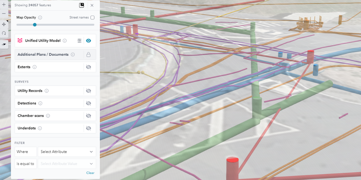
What is 3D Utility Mapping?
3D utility mapping is the process of creating a three-dimensional GIS model of an area to comprehensively map its utilities, including network data on potable water, stormwater, wastewater, gas, communications, electricity, and any subsurface anomalies. This mapping technique goes beyond traditional 2D data by adding depth and width to identified assets, providing a more accurate understanding of the underground environment.
Benefits of 3D Utility Mapping
3D utility mapping offers a better understanding of existing infrastructure, crucial for both greenfield and brownfield construction. 3D utility mapping can highlight conflicts in historic asset plans informing strategic decision-making and improving resource allocation in investigations. Utilizing 3D utility maps enable project managers and designers to undertake data-driven simulations and test different scenarios to optimize risk assessment. The end result is reducing the risks of utility-related incidents that can cause major budget blowouts and over runs.
Case Study: Enhancing Infrastructure Projects through 3D Utility Mapping - Birmingham's I-20/I-59 Corridor Project
Project Scope
Birmingham's I-20/I-59 interchange is Alabama’s busiest road corridor servicing more than 160,000 vehicles per day. Built in the 1960s, this traffic volume far exceeded its original traffic capacity, resulting in over 600 accidents from 2015 to 2019. The infrastructure was functionally obsolete and full reconstruction was desperately required to enhance functionality, safety, and overall capacity. The project spanned 3.5-miles with an estimated budget of USD 750 million, which included construction work for 36 bridges, roadway widening, and utility work.
The Alabama Department of Transportation (ALDOT) faced a tight 14-month construction schedule due to the escalating number of road users each year. The project's success hinged on accurate information exchange, efficient coordination, and precise decision-making.
Integration of 3D Utility Mapping and Data Sharing
Understanding the potential impact of underground utilities on project timelines, ALDOT made a strategic investment in 3D utility mapping. The intention was to coordinate data access and information exchange among multiple offices and utilities to manage costs. ALDOT provided contractors with a full 3D model prior to accepting bids, giving contractors a thorough understanding of the site and enabling them to make informed decisions during the bidding process. The 3D model further helped ALDOT to effectively convey the design to the people of Birmingham, meeting its responsibility to the public to not only build safe infrastructure but also save public money.
Project Impact and Cost Savings
Data sharing across project stakeholders streamlined workflows among consultants, saving ALDOT an estimated USD 50,000 and 40,000 resource hours with an additional 36-days in delivery time.
The 3D utility map facilitated clash detection, revealing over 1,100 design and construction clashes. This proactive identification prevented costly utility relocations, resulting in savings exceeding $10 million and 65-days in construction time.
How Reveal can Support Your Roading Project
Reveal’s products and services are designed to support large roading infrastructure projects through the full lifecycle of Subsurface Utility Engineering (SUE) practices. Reveal offers conflation of all historical utility data from existing plans and aerial imagery as well as non-invasive investigations using-vehicle-mounted multi-channel GPR to locate utilities and assess pavement thickness throughout road corridors. Reveal consolidates all collected data to deliver a fully digital 3D utility map of the project area through its software. Reveal’s software integrates seamlessly with your asset management systems and design software, providing intuitive and shareable utility data for all stakeholders to achieve cost and time savings and support risk mitigation. As shown in Birmingham's I-20/I-59 Corridor Project, this technology has the potential to save millions of dollars in project budget and time.
To learn more, visit reveal.nz.
![ESM Sidebar Ad[87]](https://excavationsafetyalliance.com/hubfs/ESM%20Sidebar%20Ad%5B87%5D.gif "ESM Sidebar Ad[87]")


Comments