
There's no escaping the digital revolution. In today's technology-driven society, nearly every industry has been impacted by digital solutions. Hospitals and healthcare systems are leveraging technology to enhance the patient experience, digital currency has modernized the finance industry, energy providers are creating sustainable energy sources, and so on. For surveying practitioners, new technology is transforming how underground facilities are traced and mapped.
While Subsurface Utility Mapping (SUM) has gained momentum and recognition in recent years, locating and mapping underground facilities for design and construction has been a common practice for decades. In Boston in the late 1890s, the Massachusetts Transit Authority (MTA) project owner recognized the need to map the underground environment to understand the underground workings before breaking ground and building the first-ever subway system. After receiving inaccurate data from the asset owners, the design team took matters into their own hands. They set out to improve the plan designs by mapping the subsurface facilities using traditional survey methodologies and non-destructive steam powered excavators while a group of utility surveyors prepared the base maps. To avoid the populated above ground streets, utility surveyors tunneled under the streets to observe the utilities in a trenchless program. At this time, tools and technologies were rudimentary; utility locators worked without the benefits of digital survey instruments, remote sensing technologies, and digital processing and sharing platforms. Yet, they were able to design an incredible piece of infrastructure that’s still in use today.
In addition to leaving behind a valuable piece of transportation infrastructure, the project owner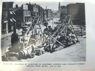 provided legacy data for the underground facilities and information on the foundation elements of the surrounding historical buildings. Our peers also shared best practices for locating utilities and outlined three key goals to keep in mind during collection: provide accurate plans of utilities and nearby foundation elements for efficient designs, create utility-enabled contracts to relocate facilities when necessary, and deliver reliable information to project contractors for underground damage prevention programs.
CREATING EFFICIENCY WITH TECHNOLOGICALLY ADVANCED PIPE LOCATORS AND GROUND PENETRATING RADAR SYSTEMS (GPR)
Since the MTA project, land surveyors have benefited from the evolution of survey tools that make locating and mapping above and below ground more effective and efficient. Pipe locators have transformed from practical, simple utility tracing devices into Global Positioning Systems (GPS) and Ground Penetrating Radar Systems (GPR).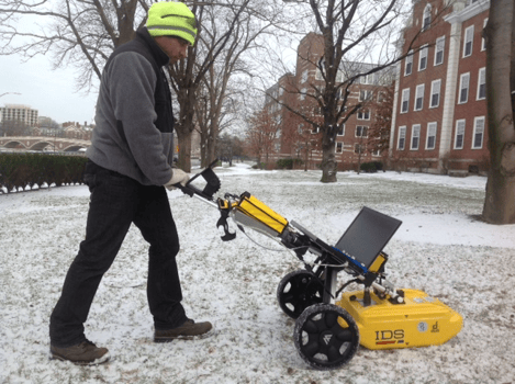
While the fundamental components of pipe and cable locators have remained the same, sophisticated bells and whistles have been added with each generation of upgrades. Today, pipe and cable locators have more tracing frequencies, Bluetooth connectivity to allow GPS for positioning the trace, and revamped display screens. Additionally, with increased non-metallic conduits, technicians often have to use supplemental technologies such as sondes, rodding reels, and CCTV inspection tools to locate pipes that may otherwise go unlocated. For practitioners, these technological advancements have allowed us to acquire data faster and create detailed plans for designers, engineers, and project owners who need to make accurate and actionable decisions.
Reflecting on the early days of GPR, many utility surveyors began dragging single antenna systems across a site in a grid pattern to capture information. With modern advancements, GPR has been mounted on small, light wheel carriages with GPS and wheel encoders for positioning. These once rugged systems now have multi-functioning tablets connected to the antennas, replacing the old paper reel for viewing the subsurface results. Utilizing cloud connectivity, facility owners, managers, and supervisors can observe the parameters of a location on a dashboard from an office, even if it’s thousands of miles away. This metadata is then captured and stored to aid in productivity, provide a positive response to a locate request, accurately position a line trace for the future, update GIS databases, and even mitigate claims in the event of a dispute.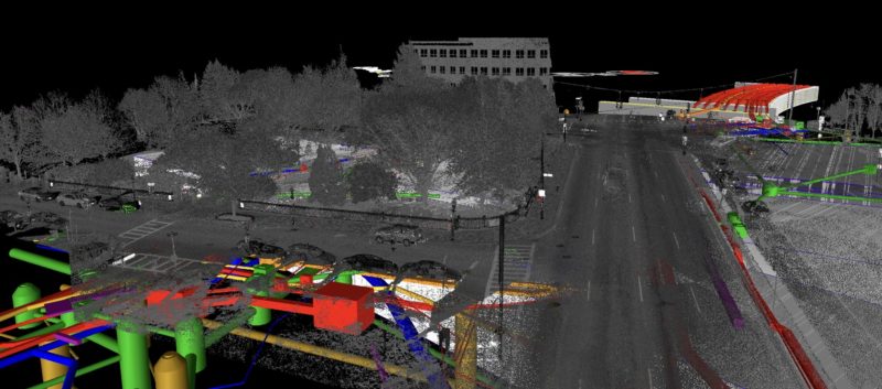 THE BUILDING BLOCKS FOR SAFER ENVIRONMENTS
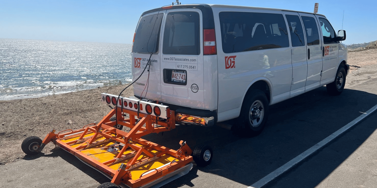
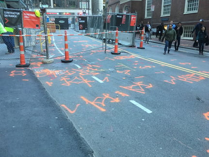
When utilizing traditional SUM methods, such as pushcart systems and cable and pipe locators, crew members are exposed to the hazards of roadways. According to a report based on data from the U.S. Occupational Safety and Health Administration (OSHA), almost 40% of pedestrian fatalities in work zones were on-the-clock employees primarily engaged in utility and surveying work. Arguably, the most important benefit of modernized technology in our industry is the improved safety measures provided during utility data collection, especially in high traffic, fast-moving areas such as highways. For example, vehicle-mounted, wide-array, and multi-frequency GPR systems allow geospatial mapping teams to map above- and belowground environments from inside a vehicle, dramatically reducing their risk of injury. Furthermore, if more pressure was applied to project owners through laws and regulations, project costs would be lower, timelines would be met, and more lives would be saved.
The utility data collected from these systems can also be used to develop climate-resilient infrastructure and rebuild infrastructure following significant events. Investing in a 3D property map and understanding the topography of your site will enable planners, engineers, and facility managers to locate the high-risk areas and design mechanisms to avoid damaging events. While there’s an upfront investment, every $1 spent on climate mitigation activities saves $6 in response and recovery costs, according to a study conducted by the National Institute of Building Sciences (NIBS).
POWERED BY TECHNOLOGY: THE FUTURE OF LAND SURVEYING
As technology continues to evolve, so will our methods and best practices. In the coming years, we anticipate that new geophysical instruments will enter the market and compete for technicians’ attention. For example, firms are developing new electromagnetic locators to mount onto multi-sensor vehicles and exploring the use of drones to carry GPR and other magnetometer sensors. While the economics of some of these systems will likely prevent widespread adoption, other sophisticated geophysical instruments traditionally used in geology and archaeology may break into our industry and be adapted for subsurface utility investigations.
Additionally, as cloud-based data storage continues to soar in popularity, we expect new cloud-based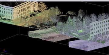 solutions to enter the market. GIS depositories, a new data-storage concept that houses utility information from public and private projects, could also enter our industry. While these methods will not replace paint markings for underground utilities used by 811 responders and contractors, they will help us reach an advanced level of reliable and accessible data.
 Finally, as we’ve observed in other industries, the potential of AI, as a threat or an advantage, is still unknown for land surveyors. While it’s very unlikely that ChatGPT or the other commercially available AI programs will be able to replace us, there’s certainly an opportunity for the technology to assist us and enhance our industry. As proven by our ancestors on the MTA, technology can be a huge asset in project efficiency and safety, but going back to the basics and following proven best practices can also and future generations of utility surveyors up for continued success.
To learn more about DGT’s Subsurface Utility Mapping process, visit dgtassociates.com/contact.
![ESM Sidebar Ad[87]](https://excavationsafetyalliance.com/hubfs/ESM%20Sidebar%20Ad%5B87%5D.gif "ESM Sidebar Ad[87]")


Comments