
If there is a utility damage today and you don’t have a complete file proving that you, as the excavator, are not-at-fault prior to the occurrence of a damage, it is very difficult to defend damage claims.
We live in a world of utility damage prevention where capture of “data and documentation” via best practices being used “properly” by all stakeholders is essential. Fundamentally, every excavator needs to document their own efforts and the efforts of the locators to prevent damage as if a damage has already occurred, to have a complete file for defending utility damage claims when the excavator is not-at-fault.
Documentation of the entire site is necessary because there is no way to predict where damage might occur. If the excavator waits for a damage to occur to begin collecting documentation “that they are not-at-fault” the most critical information, like the location of locate marks in proximity to the damage, may not be recoverable because of work activities destroying marks.
Here is a Site Checklist for Success Documentation done by field teams that is critical to successfully defend utility damage claims when the excavator is not-at-fault:
Have you reviewed the positive response on this job site to be certain all facilities are either marked or there is No Conflict? Verify Yes or No.
As long as 811 has been in place, maybe as high as 90% of all field workers (today) including foremen, and far too many superintendents, do not know what a “Positive Response” is or what its value is with regard to their ability to dig safely without causing damage. The office always provides the field crew a copy of a “paper ticket” as proof that 811 was called for a locate for the area being excavated, meeting regulatory compliance. Far too many field teams never verify the documentation for Positive Response and seldom have access to the most current Positive Response.
When there is a damage, the number one excavator defense is, “the locator failed to mark” the facility that was damaged. The number one rebuttal from the locator is, “your locate ticket clearly documented the damaged facility had not been marked yet,” which indeed is the case for the majority of claims investigated.
In Florida, as an example, there are 23 Positive Response codes and only three confirmed facilities are marked, not a conflict, or in the ticket area. The other 20 response codes all mean that facilities have not been marked or additional action must be taken prior to excavating to be certain all marking issues have been addressed.
Have you photographed all the locate marks to confirm each of the facilities that are listed as “marked” in the Positive Response are actually marked? Verify Yes or No.
Just about every excavator agrees that photos of locate marks is a good idea but very few do a great job of documenting them. A huge provider of directionally drilled facilities using hundreds of subcontractors told all of his subcontractors they would assist in the defense of damage claims if they had just one thing: photos of locate marks. If the sub failed to take photographs the provider simply deducted the cost of the damage from their next billing. The amount of damages sustained by hundreds of subcontractors was incredibly small. What was the success mechanism? This wise provider knew that requiring the photos created focus on locate marks and the facilities below.
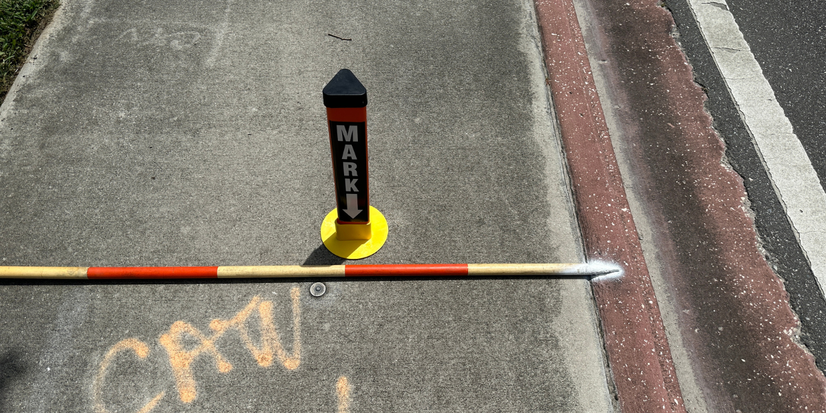
While simply taking photos of locate marks has proven to be a powerful tool to get excavators to focus on buried facilities, there is more that needs to be done to make the photography valuable for defending utility damage claims. Very common to the excavation industry are damage kits, and the documentation strategies for damages using marker pylons for locate marks and the damage. Placing a giant ruler on the ground to document the distance from the damage to the locate marks is well established as a best practice, including taking photos at different distances from the damage to document reference points that all contribute to providing a defensible position after a damage. Many of the same documentation strategies for documenting damage apply to documenting locate marks when no damage has occurred.
The use of the pylons to highlight locate marks in photos is a powerful tool. Many excavators have range poles with red and white bands that are one foot in length. One excellent method to document distances around locate marks before a damage occurs is to lay the butt end of the range pole on the ground aligned against some fixed object like a curb line or sidewalk and place the range pole over the locate marks. Spraying a white “dot” at each end of the range pole will allow the excavator to recreate the position of the locate marks extremely accurately after the mark has been destroyed by construction activities. All the excavator needs to do is take photos of locate marks with the entire range pole (usually 12 feet long) in the photograph to automatically provide all the context necessary for great documentation.
Have you potholed facilities near work areas to confirm the accuracy of the marks AND taken measurements from locate marks to buried facilities -- documenting measurements with photos for depth and distance from the mark? Verify Yes or No.
We started this discussion with the statement “every excavator needs to document their own efforts and the efforts of the locators to prevent damage as if a damage has already occurred”. Regulatory guidance and best practices all focus on potholing to verify the location of buried facilities. Yes, it is important for the excavator to physically uncover buried facilities to avoid damage. Potholing is the greatest opportunity the excavator has to check and confirm the accuracy of utility locate marks. The documentation of potholing should be the same as the documentation of damage. Place the range pole on the ground with the butt end next to some fixed object and lay it over the pothole. Place the big ruler down in the hole to photograph the depth of the facility. Take another photo with the yellow ruler over the center of the buried facility to photograph the distance of the locate mark from the facility. This “locate accuracy” documentation from potholing could be one of the greatest opportunities for both excavators and locators to work together to prevent damage.
Currently, many locators have internal standards for verifying the accuracy of field locator marks when a damage has not occurred. Not many, if any, locator’s pothole facilities to confirm the accuracy of locate marks. The excavator does for the locator what the locator cannot do for themselves - they verify the accuracy of locate marks every day. Generally, the only time this information is communicated to the locator from the excavator is when there is damage. All utilities and locating companies want to know when their locators are not providing accurate marks. They all want to know when to take corrective action to improve accuracy of locating. We hear stories every day about inaccurate locate marks (sometimes by 3 to 10 feet) and how facilities are marked on the wrong side of the road, and unless there is a damage, the facility owner never finds out the error occurred. Excavators: share your locate accuracy documentation with the facility owners and their locators.
Have you photographed all gas line marker pylons in or near work site to confirm all gas lines are marked? Verify Yes or No.
The large gas line marker pylons are spaced such that it is very possible for a utility locate area to have a large diameter gas line in a locate area with only small diameter gas lines marked. It is important for the excavator to drive to the vicinity of a project looking for and documenting surface indications of large pipelines below that could extend into their work area.
Have you photographed all fiber optic pylons in or near work area to verify fiber lines are marked? Verify Yes or No.
The practice of photographing fiber optic pylons is related to how very expensive a damage can be to an excavator, should they be at fault. Focus, focus, focus on what can bite you financially or kill you.
Have you photographed all surface indications of facilities below that do not have marks and reported findings to 811 to determine who may have failed to mark? Verify Yes or No.
Industry experience investigating damage claims has shown that somehow many people in the field miss some of the most obvious surface indications of buried facilities. For example, the surface indication may be a pedestal in a residential neighborhood a couple hundred feet away from a water service installation. If the locator makes a mistake and fails to mark a utility, is the excavator responsible because there is a surface indication of a buried facility? Sure, it’s possible to make a defense for a damage claim on a single address ticket in a case like this. The point of this is doing things as an excavator that prevent damage so there is no need to have a defense for damage.
We have discussed six damage prevention practices that experience has proven to generate success in preventing damage and injury. These same practices provide the best defenses against damage claims with all the necessary information to prove the excavator is not at-fault and have all the necessary documentation in place before the damage occurs. Is it any surprise this documentation to defend damage claims is also the best tool to prevent damage? You pick why you do it.
The problem is:
- Communicating these practices to field people using technology.
- Providing technology for field people to document these practices are done every day and on every job.
- Providing technology to help the field crew understand exactly what the positive response means and confirm their understanding.
- Providing technology to facilitate the ability of field people to take photos and make relevant notes to provide the defense that the excavator is not-at-fault for damage, should it occur, when that is indeed the case.
Today, that technology platform exists. Of course, the technology is easy to use on smart phones and the software performs on the desktop the same way as in the mobile platform except for taking photos. The moment a photo is taken in the field it populates in the desktop environment. When the field person says they photographed all the locate marks it can be instantly confirmed in the office.
For the first time senior management of any excavator organization can commit to following best practices for utility damage prevention and know every second of every day at their desk that the field teams, including hundreds of subcontractors, are also onboard following the vision of management.
![ESM Sidebar Ad[87]](https://excavationsafetyalliance.com/hubfs/ESM%20Sidebar%20Ad%5B87%5D.gif "ESM Sidebar Ad[87]")


Comments